地理漫步·世界地理英语30篇(1)
21 / 30
正在确认阅读权限…
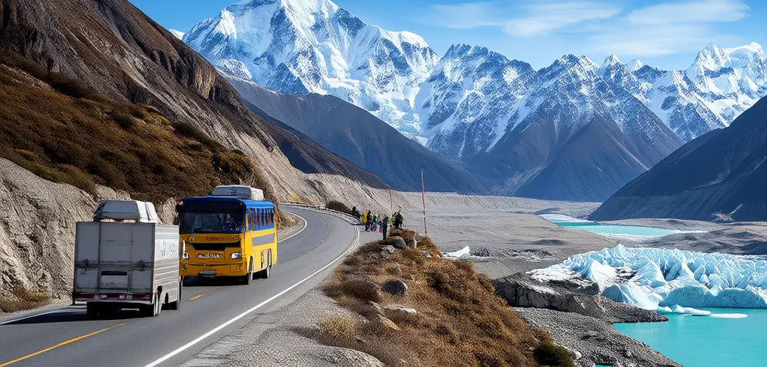
Karakoram Highway and Glacial Dynamics in High-Altitude Corridors
喀喇昆仑公路与高山冰川
-
The Karakoram Highway crosses glaciers, moraines, and active rockfall zones while linking China’s Xinjiang to northern Pakistan.喀喇昆仑公路连接中国新疆与巴基斯坦北部,穿越冰川、冰碛和活跃的岩崩区。
-
It traverses the Baltoro Glacier—one of Earth’s longest non-polar ice streams—at elevations exceeding 4,700 meters.它途经地球最长的非极地冰川之一——巴尔托洛冰川,海拔超过4700米。
-
Glacial meltwater feeds seasonal rivers that sustain irrigation but also triggers flash floods when supraglacial lakes drain suddenly.冰川融水补给季节性河流,支撑灌溉,但表碛湖突发溃决也会引发山洪。
-
Road engineers install avalanche sheds and tunnel bypasses where steep valley walls shed ice and debris year-round.在陡峭谷壁常年崩落冰雪与碎屑的路段,道路工程师修建防雪棚和绕行隧道。
-
Permafrost degradation beneath roadbeds causes uneven settlement, requiring thermosyphons to stabilize foundations in warming summers.路基下多年冻土退化导致不均匀沉降,需靠热虹吸管在变暖的夏季稳定地基。
-
Satellite imagery reveals rapid thinning of glacier tongues below 5,200 meters, altering long-term runoff timing and volume.卫星影像显示,海拔5200米以下冰川末端正快速变薄,改变长期径流的时间与总量。
-
Local communities rely on glacial melt for spring wheat sowing, yet face increasing unpredictability in streamflow onset.当地社区依赖冰川融水播种春小麦,却面临径流起始时间日益不可预测的挑战。
-
The highway’s maintenance crews monitor crevasse formation and ice dam risks using ground-penetrating radar and drone surveys.公路养护人员利用探地雷达和无人机巡检,监测裂缝发育与冰坝风险。
-
Glacier surges—like those of the Kutiah Lungma Glacier—have buried road sections under ice and debris without warning.冰川跃动(如库提亚伦玛冰川)曾毫无预警地掩埋路段,覆以冰体与碎屑。
-
Future upgrades prioritize climate-resilient design, including elevated bridges above projected flood corridors and reinforced avalanche galleries.未来升级将优先采用气候韧性设计,包括架设于预估洪水廊道之上的高架桥及加固型防雪廊道。