地理漫步·世界地理英语精读30篇(4)
14 / 30
正在确认阅读权限…
Geography and Environmental Autonomy: Indigenous Fire Regimes as Sovereign Landscape Practice (2026-D002)
地理与环境自主性:原住民火耕制度作为主权性景观实践
-
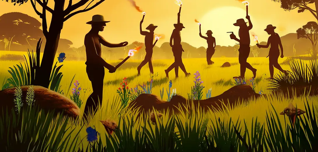
Across northern Australia, Aboriginal rangers apply mosaic burning techniques refined over sixty thousand years to reduce wildfire intensity and regenerate biodiversity.在澳大利亚北部,原住民护林员运用历经六万年精炼的马赛克式焚烧技术,以降低野火强度并促进生物多样性再生。
-
These practices are not ‘traditional knowledge’ in the passive sense but active assertions of jurisdiction over fire-prone savanna ecosystems.这些实践并非被动意义上的‘传统知识’,而是对易发火灾的热带稀树草原生态系统行使管辖权的积极主张。
-
Burn timing, frequency, and patch size reflect intimate understanding of soil moisture gradients, eucalyptus oil volatility, and marsupial migration corridors.焚烧时机、频次与斑块大小,均体现着对土壤湿度梯度、桉树油挥发性及有袋类动物迁徙廊道的深刻理解。
-
State fire agencies once criminalized these burns; today, joint management agreements recognize them as legally binding landscape governance instruments.过去,州级消防机构曾将此类焚烧定为犯罪;如今,联合管理协议承认其为具有法律约束力的景观治理工具。
-
The autonomy lies not in isolation but in calibrated interdependence—with meteorological data, drone surveillance, and carbon credit frameworks integrated on Indigenous terms.这种自主性不在于孤立,而在于经过校准的相互依存——气象数据、无人机监测和碳信用框架均按原住民主导方式整合。
-
Fire maps produced by Yolŋu elders overlay GPS coordinates with songline names, embedding sovereignty into every hectare’s metadata.尤尔古(Yolŋu)长老绘制的火情图,将GPS坐标与歌线名称叠加,使每一公顷土地的元数据都承载着主权。
-
Unlike top-down prescribed burns, this regime refuses uniformity: one clan may ignite at dawn while another waits for cloud cover signaling ancestral permission.不同于自上而下的计划焚烧,该制度拒绝千篇一律:一个氏族可能在黎明点火,另一个则等待云层出现——那是祖先许可的信号。
-
It challenges Western conservation orthodoxy by treating disturbance not as threat but as necessary relational maintenance between people and biota.它挑战西方保护主义正统观念,将干扰视为人与生物间必要关系维系的手段,而非威胁。
-
International climate policy increasingly cites these regimes as models for ‘just adaptation’—where mitigation serves cultural continuity, not just emissions targets.国际气候政策日益援引此类制度作为‘公正适应’范本——减缓措施服务于文化延续,而不仅限于减排目标。
-
Funding mechanisms now require co-designed monitoring protocols, ensuring ecological metrics never override ceremonial access rights to burn sites.当前资金机制要求采用共同设计的监测规程,确保生态指标绝不能凌驾于仪式性进入焚烧地点的权利之上。
-
This is geography as jurisdiction: land management inseparable from law, language, and intergenerational accountability.这是以管辖权为内核的地理学:土地管理与法律、语言及代际责任密不可分。
-
Environmental autonomy here means deciding *when*, *how*, and *with whom* fire speaks—and who listens.此处的环境自主权,意味着决定火何时言说、如何言说、与谁言说——以及谁来倾听。