地理漫步·世界地理英语精读30篇(5)
20 / 30
正在确认阅读权限…
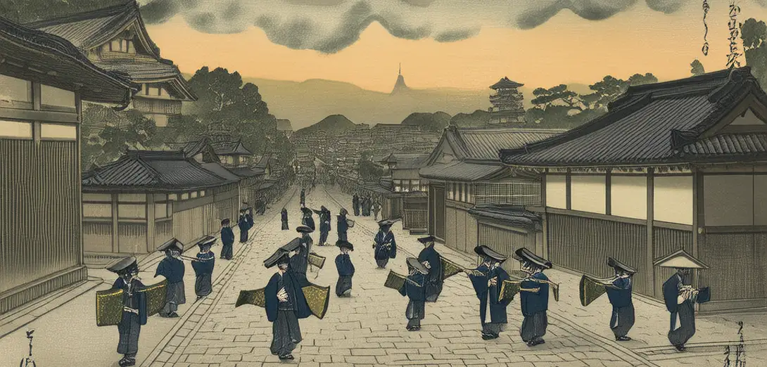
Kyoto’s Kanda Matsuri Procession: Urban Topography as Sacred Cartography in Post-Industrial Japan
京都神田祭巡游:后工业日本都市地形中的神圣制图学
-
Each May, Kyoto’s Kanda Matsuri routes traverse 23 historically contested neighborhoods, retracing Edo-era shrine alliances dissolved by Meiji-era urban planning.每年五月,京都的神田祭巡行路线穿越23个历史上存在争议的街区,重溯明治时期城市规划所瓦解的江户时代神社联盟。
-
The procession’s path avoids modern subway tunnels and high-rises not out of superstition but because those infrastructures severed ancestral geomantic alignments still legible in street gradients and stone drain placements.巡行路线避开现代地铁隧道和高楼,并非出于迷信,而是因为这些基础设施切断了至今仍可从街道坡度与石制排水沟布局中辨识的祖先风水格局。
-
Shinto priests carry mikoshi shrines along slopes calibrated to channel spring meltwater from Higashiyama—now a hydrological memory encoded in ritual pacing.神道教祭司沿坡道抬着神轿前行,坡度经精密测算,用以引导东山春日融雪水——如今这一水文记忆已编码于仪式行进节奏之中。
-
Municipal planners consult shrine archivists before approving redevelopment, treating cadastral maps as incomplete without ritual itineraries.市政规划者在批准再开发项目前必咨询神社档案员,视地籍图若无仪式巡行路线则不完整。
-
Unlike Western heritage preservation, this practice treats spatial continuity as performative, not static—resilience measured in unbroken procession years, not restored façades.不同于西方遗产保护理念,此实践将空间连续性视为动态展演而非静态保存——其韧性以巡行年份是否 uninterrupted 衡量,而非立面修复程度。
-
The 2022 route adjustment bypassed a newly constructed luxury condominium complex after geomancers detected disrupted qi flow beneath its foundation pile driving.2022年巡行路线绕开一座新建豪华公寓楼,因风水师探测到其打桩施工扰乱了地基下方的气流。
-
Corporate sponsors fund portable mikoshi lifts only if engineers submit alignment reports certified by both city surveyors and Shinto elders.企业赞助商仅在工程师提交由市测绘员与神道教长老共同认证的方位校准报告后,才资助便携式神轿升降设备。
-
This is not nostalgia but adaptive territoriality: where land-use law and liturgical sequence jointly govern vertical development rights.这并非怀旧,而是适应性领地观:土地使用法规与礼拜仪轨序列共同规约垂直开发权。
-
Even Google Maps now layers ceremonial paths over satellite imagery—a quiet institutionalization of sacred topography in municipal GIS.连谷歌地图如今也在卫星影像上叠加祭祀路径——神圣地理正悄然制度化为市政GIS的一部分。
-
The matsuri’s endurance reflects Kyoto’s refusal to treat urban form as separable from cosmological obligation.该祭典的延续,体现京都拒绝将城市形态与宇宙论义务割裂。
-
Its geography is not drawn on paper but walked, carried, and recalibrated annually against shifting groundwater tables and shareholder mandates.其地理并非绘于纸上,而是靠人行走、肩扛,并每年依据地下水位变化与股东指令重新校准。
-
Here, sovereignty resides less in zoning ordinances than in the collective breath-synchronization of bearers ascending Nishiki slope at precisely 3:47 a.m.此处的主权,更多寓于抬轿者集体呼吸同步、于凌晨3时47分精准登上锦市场坡道的瞬间,而非区划条例之中。