地理漫步·世界地理英语30篇(4)
20 / 30
正在确认阅读权限…
The Yucatán Peninsula: Karst Hydrology and Sinkhole-Dominated Freshwater Access
尤卡坦半岛:喀斯特水文与天坑主导的淡水供给系统
-
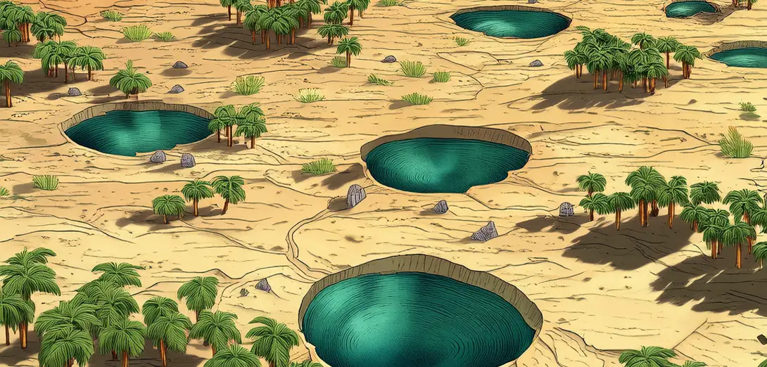
The Yucatán Peninsula lacks surface rivers due to its porous limestone bedrock.尤卡坦半岛因多孔石灰岩基岩而缺乏地表河流。
-
Rainwater rapidly infiltrates through fractures, forming extensive underground aquifers and caverns.雨水迅速通过裂缝渗入地下,形成广阔的地下含水层和洞穴。
-
Cenotes—natural sinkholes—are windows into this subterranean water network.天坑——天然的塌陷洼地——是窥探这一地下水资源网络的窗口。
-
These features result from limestone dissolution and roof collapse over millennia.这些地貌是数千年间石灰岩溶解及洞顶坍塌形成的。
-
Cenotes vary in size, depth, and connectivity, creating localized freshwater oases in dry seasons.天坑在大小、深度和连通性上各不相同,旱季时成为局部淡水绿洲。
-
Their spatial distribution reflects underlying joint patterns and regional groundwater flow directions.其空间分布反映了地下节理格局和区域地下水流动方向。
-
Maya civilization strategically settled near cenotes for reliable water and ritual significance.玛雅文明战略性地在天坑附近定居,以获取稳定水源并满足宗教仪式需求。
-
Modern tourism and agriculture now strain aquifer recharge rates across the peninsula.如今,旅游业和农业正加剧半岛含水层补给速率的压力。
-
Saltwater intrusion threatens coastal cenotes as sea levels rise and pumping increases.随着海平面上升和抽水量增加,海水入侵正威胁沿海天坑。
-
This karst landscape demonstrates how geology dictates hydrological accessibility and human settlement patterns.这一喀斯特地貌表明,地质条件决定了水文可获取性与人类聚居模式。