世界文化英语精读30篇(4)
28 / 30
正在确认阅读权限…
Namibian Red Desert San Storytelling: Sand-Print Cartography and Intergenerational Epistemic Continuity
纳米比亚红沙漠桑人叙事:沙印制图与代际知识连续性
-
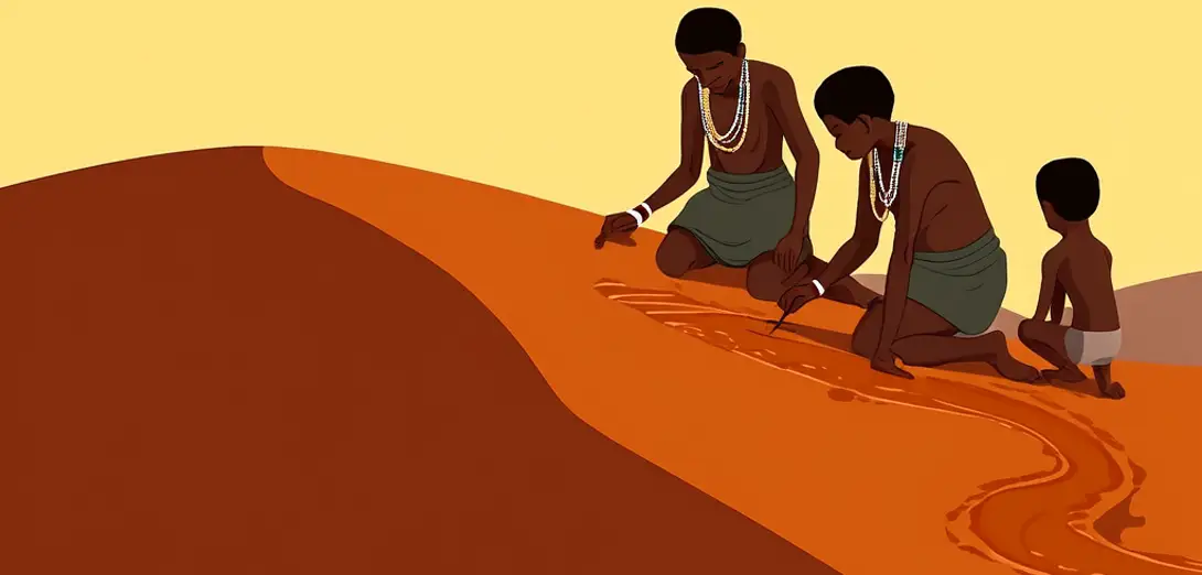
San elders in the Namib Desert trace animal tracks not to hunt but to inscribe evolving water-table narratives onto wind-polished dune surfaces using iron-rich ochre paste.纳米比亚沙漠中的桑族长老追踪动物足迹,并非为了狩猎,而是用富含铁的赭石糊,在风蚀沙丘表面刻画不断演化的地下水位叙事。
-
Each sand-print sequence encodes borehole depth data, rainfall variance since 1962, and uranium deposit boundaries negotiated with state geologists in 2004.每组沙印序列编码着钻孔深度数据、自1962年以来的降雨量变化,以及2004年与国家地质学家协商划定的铀矿边界。
-
Youth apprentices learn cartographic grammar through tactile memory—fingertips identify thirty-seven distinct grain textures corresponding to aquifer strata layers.青年学徒通过触觉记忆学习制图语法——指尖可分辨三十七种不同颗粒质感,对应含水层的地层结构。
-
When drought forces relocation, families don’t follow GPS coordinates but replicate ancestral sand-print sequences in new locations, thereby activating dormant hydrological knowledge.干旱迫使迁居时,家族不依赖GPS坐标,而是在新地点复刻祖先沙印序列,从而激活沉睡的水文知识。
-
These ephemeral maps last only forty-eight hours, making their transmission an urgent pedagogical act rather than archival preservation.这些短暂的地图仅存续四十八小时,使其传承成为一项紧迫的教学行为,而非档案式保存。
-
German colonial surveyors’ 1906 triangulation points appear in San oral maps as ‘broken stars’—a critique of Euclidean imposition on fractal desert topography.德国殖民测绘员1906年设立的三角测量点,在桑族口述地图中被称为‘破碎的星辰’——这是对欧几里得几何强加于沙漠分形地貌的批判。
-
Contemporary San cartographers now overlay drone-collected thermal imagery onto sand prints, creating hybrid datasets used by Namibia’s Ministry of Water Affairs.当代桑族制图师如今将无人机采集的热成像图叠加于沙印之上,生成供纳米比亚水资源部使用的混合数据集。
-
Storytelling sessions occur only at dawn, when surface temperature differentials make subsurface moisture gradients legible to trained eyes—a temporal protocol enforced by elders.讲述活动仅在黎明举行,此时地表温差使地下水分梯度在训练有素的眼中清晰可辨——这一时间规范由长老严格执行。
-
Sand-printing avoids permanent markers not from scarcity but as deliberate resistance to extractive land registration systems imposed under the Communal Land Reform Act.沙印摒弃永久标记,并非出于匮乏,而是刻意抵制《集体土地改革法》下强加的掠夺性土地登记制度。
-
Each narrative cycle concludes with the erasure of the final print—symbolic affirmation that knowledge resides in practice, not possession.每个叙事周期以抹去最后一道沙印告终——象征性地确认:知识存于实践,而非占有。
-
International hydrologists attend these sessions not as observers but as certified learners bound by San intellectual property protocols.国际水文学家参加这些活动,身份并非观察者,而是经桑族知识产权规程认证的学习者。
-
This is geography as relational ethics: mapping as reciprocal obligation between people, sand, and subterranean time.这是一种关系伦理学意义上的地理学:制图即人、沙与地下时间之间的相互责任。