地理漫步·世界地理英语精读30篇(2)
30 / 30
正在确认阅读权限…
Tundra Permafrost Archives: Ice-Wedge Polygons and Indigenous Chronologies of Ground Truth
苔原永冻土档案:冰楔多边形与原住民的地面真实时间谱系
-
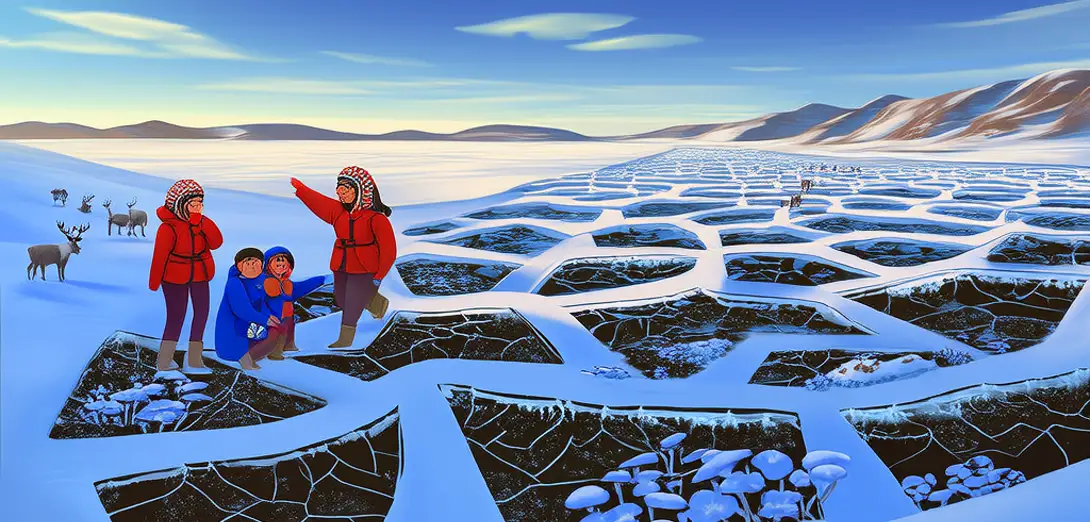
Ice-wedge polygons in Arctic tundra preserve millennia of freeze-thaw cycles, their geometry encoding precipitation, temperature, and snowpack history.北极苔原的冰楔多边形记录了数千年的冻融循环,其几何形态编码了降水、气温与积雪历史。
-
Inupiat hunters read polygon cracking patterns to predict winter trail safety—interpreting thermal stress as narrative, not noise.因纽皮亚特猎人通过观察多边形裂纹模式预测冬季路径安全性——将热应力解读为叙事,而非杂音。
-
Permafrost cores contain ancient plant DNA and microbial signatures, yet elders identify ecosystem shifts through changes in lichen growth on polygon rims.永久冻土岩芯保存着远古植物DNA与微生物痕迹,而长者则通过多边形边缘地衣生长变化识别生态系统变迁。
-
Thaw slumps expose stratified layers where 10,000-year-old mammoth bones lie adjacent to 20th-century mining debris—collapsing geological and colonial time.热融滑塌暴露出层状沉积,一万年前的猛犸象骨骼与20世纪采矿废料并置——地质时间与殖民时间在此坍缩。
-
Remote sensing detects subsidence, but community monitors log erosion rates using fixed stakes aligned with ancestral hunting routes.遥感可探测地面沉降,但社区监测员沿祖传狩猎路线设置固定桩标,实地记录侵蚀速率。
-
School science programs now co-teach ice-core drilling with oral mapping of polygon names—each reflecting distinct soil texture, drainage, or spiritual significance.学校科学课程如今联合讲授冰芯钻取与多边形名称的口述地图绘制——每个名称对应独特的土壤质地、排水特征或精神意义。
-
Infrastructure engineers consult thaw-depth maps co-produced with elders who correlate polygon geometry to caribou calving ground stability.基建工程师参考由长者共同绘制的融化深度图,因长者能将多边形几何形态与驯鹿产仔地稳定性关联起来。
-
The term ‘permafrost’ misleads: it implies permanence, whereas Inuit and Sámi vocabularies describe dynamic ground states—‘breathing earth’, ‘sleeping soil’, ‘weeping ground’.‘永久冻土’一词具有误导性:它暗示永恒不变,而因纽特语和萨米语词汇却描述动态的地表状态——‘呼吸的大地’‘沉睡的土壤’‘流泪的地面’。
-
Carbon release models ignore how polygon collapse alters light penetration, triggering algal blooms that reshape entire food webs.碳释放模型忽视了多边形塌陷如何改变透光率,从而引发藻华,重塑整个食物网。
-
Ground truth here is never extracted—it is co-revealed through walking, listening, and remembering across generations.此处的‘地面实况’从不靠提取获得——而是通过行走、倾听与代际记忆共同揭示。
-
Polygons function as living chronometers: their geometry shifts faster than policy cycles, demanding governance calibrated to cryospheric time.多边形充当活态计时器:其形态变化快于政策周期,要求治理体系适配冰雪圈的时间尺度。
-
Tundra pedagogy teaches that the ground is not substrate but archive—holding stories older than writing, readable only through sustained presence.苔原教育指出,大地并非基底,而是档案——承载着比文字更古老的故事,唯有持续驻留方可读懂。